Touring Northern Israel
For many centuries, the undisputed spiritual and governmental center of the Promised Land has been Jerusalem, the unique city I am privileged to reside in. But before I moved to the Israeli capital in April 1984, I lived for more than three years in the most beautiful portion of the land, Israel’s northern Galilee. With the exception of the Golan Heights, which Israel captured from Syria in the 1967 Six-Day War, most of the Upper and Lower Galilee regions lie inside the area given to the Jewish people by the United Nations in 1947.
However, the Galilee was first given to them by God and allotted to the tribes of Asher, Dan, and Naphtali; the Golan plateau, known as Bashan, became the inheritance of the half tribe of Manasseh. Later the kingdoms of David and Solomon completely engulfed the Galilee, the Golan Heights, and beyond.
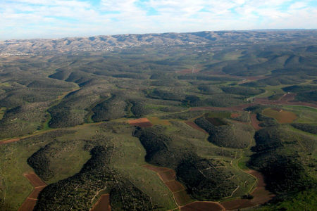
The greenest part of Israel by far, the Galilee derives its name from the historic fact that it was a crossroads of ancient travel and commerce. The renowned Via Maris trade route ran through the middle of the area, connecting Egypt and North Africa with flourishing empires like Assyria and Persia to the north and east. Known in Hebrew as Ha Galil, meaning “the circuit,” the word Galilee is also related to the word gal, meaning “wave.” That is an apt description of Israel’s Galilee region—full of tree-lined, rolling hills that gently rise and fall between fertile, farmed valleys.
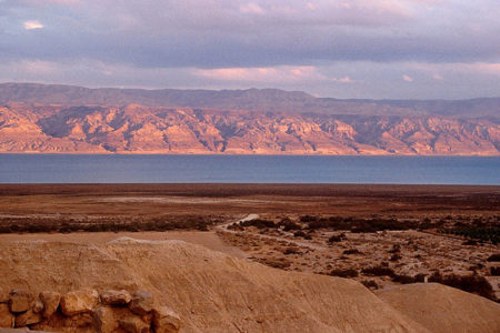
This verdant area contains the country’s only natural freshwater lake, the picturesque and often tempestuous Sea of Galilee. Called Kinneret by modern Israelis, and measuring 13 miles in length and an average of eight miles in width, the lake’s surface waters actually lie more than 700 feet below sea level, making it the lowest lake on Earth.
The pristine headwaters of the renowned Jordan River flow south from Lebanon into the fish-filled lake, supplemented by many underground springs and streams that emerge from the base of majestic Mount Hermon and from the scenic Golan Heights above the Kinneret’s eastern shore. Israeli government leaders inaugurated the National Water Carrier from the Sea of Galilee in 1964, piping thousands of gallons of potable water to more southerly portions of the semi-arid country every day.
Mount Hermon, the highest mountain peak in Israel, rises like a monarch from the northern reaches of the Galilee region and the Golan Heights. At 9,230 feet above sea level, the towering mountain actually contains three distinct peaks. One of them is within the borders of neighboring Syria; another, in Lebanon. The tallest summit, captured by Israeli forces from Syria during fierce fighting in 1967, is located just inside of Israel’s post Six-Day War boundaries. With government assistance, local Jewish entrepreneurs began to develop Mount Hermon’s seasonally icy slopes into the country’s only winter ski resort in the 1970s.
Lower Galilee
Despite possessing the Middle East’s highest mountain peaks, along with the lowest freshwater lake found anywhere on Earth, the Galilee’s overall dimensions are relatively small. The southern section, known as Lower Galilee, begins in the Mount Carmel mountain range southeast of the bustling Mediterranean port city of Haifa. It stretches east across the lush Jezreel Valley, with the Gilboa Mountains, where King Saul was slain, acting as a natural southern border. Mount Tabor, the traditional site where Jesus was transfigured many centuries ago, ascends like a diamond jewel from the northern hills that line the valley.
In the middle of the intensely cultivated valley lies the expanding Israeli town of Afula, a contemporary crossroads for many domestic Israeli travelers and for roadway commerce. The Lower Galilee ends a mere 30 miles east of Haifa at the banks of the southern portion of the Jordan River, which flows out of the southern end of the Sea of Galilee. The slow moving river cuts its swath through the center of the deepest portion of the Great Rift, a massive geological fault that separates the African and Arabian plates, running all the way from Turkey in southwest Asia to central Africa.
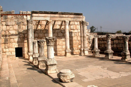
Nazareth, Sepphoris, Beth-Shean, and Megiddo were the most prominent ancient towns situated in Lower Galilee. Of the four, only Beth-Shean and Nazareth exist today. Beth-Shean is a prospering Israeli community located on the northern reaches of the Jordan Valley.
In the years since I moved to Israel 25 years ago, shovel-wielding archaeologists have uncovered one of the best preserved, Roman-era stone amphitheaters found anywhere on Earth, tucked just inside modern Beth-Shean’s city limits.
Nazareth is a constantly growing city of some 60,000 residents, a majority of them Arabs. Its most prominent landmark is the Roman Catholic Annunciation Church that commemorates the angel Gabriel’s appearance to Mary in the town where Jesus was later raised to man-hood. By the time Jesus took His first footsteps in the town of Nazareth, the entire Galilee region was completely under Roman sway.
Although He fulfilled various Bible prophecies by being born in humble circumstances in Bethlehem and dying as a sacrificial lamb in nearby Jerusalem, Jesus spent most of His life in the beautiful Galilee region. Many of His most venerated words and actions were centered there, especially near the Sea of Galilee.
Until recent years, Arab Christians outnumbered Muslims in the Jewish Messiah’s home-town. But that is sadly no longer the case due to significant Christian emigration to other countries and to a much higher Muslim birthrate. Still, Nazareth rivals Jerusalem as having the largest concentration of contemporary Arab Christians found anywhere in the Holy Land, most of them members of the dominant Greek Orthodox Church.
Upper Galilee
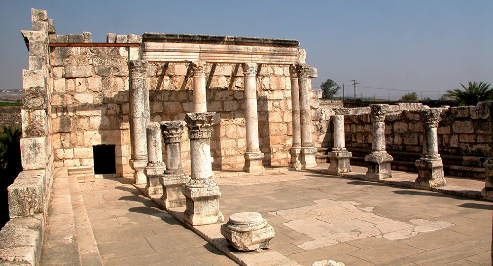
Upper Galilee extends from the Beit Hakerem Valley north of Nazareth to Israel’s hilly international border with Lebanon. The country’s second highest peak, Mount Merom, rises along the area’s northern rugged limits. Tiberias, the region’s largest urban center and most popular tourist stopover, is located on the western slopes of the Sea of Galilee, about 14 miles northeast of Nazareth. It was named after the Roman emperor who initiated the ancient building of the lakefront community. Today the streets of Tiberias are frequently filled with Christian pilgrims who bask in bright noontime sun or enjoy the warm evening lake breezes while savoring the local delicacy of Saint Peter’s fish. After being brought ashore by the many small fishing vessels that ply the lake, Saint Peter’s fish can be ordered in one of the open-air restaurants that line the lakefront stone promenade.
The oldest Jewish kibbutz, or collective farming settlement, is located just north of Tiberias. Called Kibbutz Kinneret, it was established by Zionist pioneers in 1909. Around half of Israel’s current 260 kibbutz communities are located in the Galilee region, mainly due to the rich soil and ample rainfall found there.
Among the oldest, continuous Jewish religious centers in the Holy Land is the town of Safed, built on pine-tree-lined hills north-west of the Sea of Galilee. It is widely known as one of Israel’s most exotic, modern tourist attractions, populated with many adherents of the Jewish mystical Kabbalah movement. They traverse the narrow streets, past shops featuring the works of modern Israeli painters and sculptors, many of whom also reside in the hilltop town. It has been a Kabbalah center since the 16th century.
The book of Judges records that the prophetess Deborah, assisted by Barak, led the armies of Israel in battle against Canaanite King Jabin, who ruled the region from his Upper Galilee stronghold of Hazor, north of Safed.
Known in Hebrew as Etzba Hagalil, or the “finger of Galilee,” the Galilee Panhandle stretches north from the Kinneret to the foothills of Mount Hermon. The well-watered Hula Valley, which sits like a bowl in the center of the panhandle, is known for its productive cotton fields and fragrant citrus orchards. The towns of Metulla and Kiryat Shmona are located near the area’s upper reaches. I visited Kiryat Shmona frequently while living on a northern panhandle kibbutz in the early 1980s, despite the fact that it was frequently under siege from Palestine Liberation Organization forces that fired rockets at the half deserted community from nearby southern Lebanon.
The Golan Heights
This militarily strategic area had been part of the original British Mandate over Palestine, but it was ceded to French control soon after World War I and therefore became part of modern Syria. Outnumbered Israeli forces captured the volcanic plateau from Soviet-backed Syrian soldiers in June 1967, ending nearly two decades of Syrian shelling of the Hula Valley below, which left more than 140 Israelis dead and thousands more wounded.
Despite the fact that officials in Damascus began to demand the return of the heights virtually the moment that guns fell silent at the end of the Six-Day War, the tiny Golan region has remained relatively peaceful ever since—especially after Israel rebuffed Syria’s surprise attempt to recapture it during the Yom Kippur War of October 1973.
Israeli leaders have said they will never return the vital watershed area to hostile Syrian control. The first Israeli Golan Heights settlement, Kibbutz Merom, went up in July 1967. Three years later, a dozen Jewish communities dotted the plateau. By 2005, more than 18,000 Israelis were living in 34 Israeli kibbutzim and in towns throughout the Golan Heights, despite continuing Syrian threats to retake the area in a new Middle East war.